
This is Article 18 in an ongoing series examining America's abandoned and orphaned well problem. The series opened with a single well in West Texas that came back to life, and this article returns to that event with a wider frame.
In January 2022, a well in Crane County erupted into a column of contaminated brine that ran for close to two weeks. The state records listed that well as plugged and abandoned.
At the time I treated it as a story about one well and poor records, which it was. But the event raised a question I didn't address then. A well that has been stable for decades does not reactivate on its own. Something in its surroundings has to change. In the Permian, the variable that's changing is pressure, and it's changing across an area far larger than any single lease.
The scale of produced water
People outside the business tend to picture the Permian as an oil basin. By volume it's closer to a water operation that also produces oil. The region produces roughly 6.3 million barrels of oil a day, about 40 percent of total US output, along with more than 20 million barrels of water a day, a volume that has roughly tripled since 2017 and is forecast near 22 million a day in 2025. That water is salty, sometimes radioactive, and there's little market for it. Most of it goes back underground for disposal, on the order of 16 million barrels a day, through saltwater disposal wells (SWD), more than 4,600 of them on the Texas side alone, with the remainder recycled.
The volume has also climbed steeply. Railroad Commission data show the average permitted injection for a new disposal well rose from under 10,000 barrels a day early this century to more than 20,000 by 2023. At the county level the increase is larger. In Reeves County alone, annual injected volume rose from 16.9 million barrels in 2010 to 1.2 billion barrels in 2024, according to an analysis by POLITICO's E&E News, roughly a 7,000 percent increase in fourteen years.
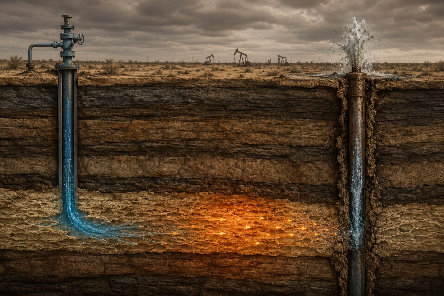
That arrangement worked for a long time because the receiving formations had room to accept the fluid. When fluid is injected into a confined system, it doesn't disappear. It raises the pressure in the formation it enters, and that pressure does not stay within the lease boundary. It migrates outward through the rock.
Pressure does not stay where it is injected
When water is injected into a permeable formation, the pore pressure in that formation rises, and that elevated pressure propagates outward through whatever pathways the rock provides. Permeable beds carry it laterally, and faults can carry it vertically. Over years of sustained high-volume injection, the background pressure in the disposal zones climbs, and the area affected by any one disposal well expands until it overlaps with its neighbors.
The result is a regional pressure field rather than a set of isolated injection sites. Once the pressure in that field is high enough, it follows the path of least resistance back toward the surface.
A century of wellbores already drilled
The Permian has been drilled continuously for more than a hundred years. Underneath the active fields sits a population of older wells that were drilled, produced, plugged, and abandoned under the standards of their era, many of them long before anyone logged cement quality or considered long-term isolation. Articles 4 and 7 covered why those barriers degrade over time. Cement shrinks and develops channels, casing corrodes, and a seal that met the standard in 1955 may no longer isolate the wellbore.
A degraded legacy well is a potential vertical conduit, but it only transmits fluid when a pressure gradient is present. For most of these wells' history, that gradient was absent. Raise the pressure in the surrounding formations, and the wellbore can become a pathway for fluid to reach the surface. The Crane County well itself didn't change; the pressure regime around it did.
Two distinct failure modes
It's worth being precise here, because these two outcomes get blended together in coverage when they shouldn't be.
The first is fluid reaching the surface or shallow groundwater. Produced water under pressure finds a compromised legacy wellbore and travels up through it, sometimes violently. The 2022 Crane County event was one example, and later surface breakouts elsewhere in West Texas were others. The damage appears as contaminated soil, ruined water wells, and salt scarring on land that previously supported cattle.
The second is induced seismicity. Elevated pore pressure reaches a fault that's already near its failure threshold, reduces the friction holding it in place, and the fault slips. Disposal-related earthquakes have occurred across the Permian for several years, which is why Texas regulators added a separate seismicity review for disposal wells located within 25 kilometers of recorded events.
Both modes share the same driver, injection-driven pressure. But the physics, the warning signs, and the appropriate mitigation differ between them, and treating them as one problem leads to poor analysis. Legacy wells are central to the first mode and largely incidental to the second.
The regulator's own assessment
I try not to lean on regulators to make my arguments, but in this case the Railroad Commission of Texas has described the mechanism more directly than I would have. In its May 2025 Notice to Operators tightening disposal permits in the Permian, the Commission wrote that the elevated risk of fluids escaping the injection interval comes from three conditions at once: large historical and current rates of saltwater disposal, increased reservoir pressure in the disposal formations, and dense historical development with numerous wellbore penetrations of those same formations.
Those conditions match the mechanism described above: high injection rates, rising reservoir pressure, and numerous old wellbores through the disposal formations. The agency that permits the activity is describing the same setup, and it changed its rules in response. Effective June 2025, new and amended disposal permits in the Permian carry an expanded, two-mile area of review built in two tiers. Inside the first half mile the review is pass or fail. The operator must document the cement and plugging records of every known well, and the permit cannot be approved if that half mile contains an orphan well, an improperly plugged well, or an offset well without adequate cement across the injection interval. Between a half mile and two miles, the requirement is less strict but still consequential: if wells in that outer ring are orphaned or carry incomplete cementing and plugging records, the permit's allowable surface pressure is reduced automatically. The permit also caps surface injection pressure so it won't fracture the confining layers, and caps daily volume based on the existing reservoir pressure. These are the most significant changes to Texas disposal permitting since the state began requiring monthly bottomhole pressure reporting in 2023.
Operators are studying it too
None of this is a fringe environmental claim, and that matters for how seriously the industry should treat it. The largest operators in the basin are funding their own research into the same problem. Chevron has published work on overpressurization of disposal reservoirs and documented what it calls influx areas, where horizontal producing wells take on water migrating from shallower disposal, in some cases along faults that connect a disposal zone to a producing formation. The same group has moved to satellite radar to monitor subsurface fluid movement and fault slip near disposal sites. ExxonMobil developed a machine-learning model to rank which of the thousands of Texas-side disposal wells are most likely to induce seismicity.
When the operators doing the injecting invest in mapping where the pressure goes, it indicates they regard subsurface migration as a real operational risk.
The academic findings align
Independent researchers are reaching the same conclusion from a different direction. Katie Smye, who leads the Center for Injection and Seismicity Research at the University of Texas at Austin, runs a basin-scale program studying how injected water moves through the Permian subsurface. Her group examines the regional flow system rather than any single lease, and its findings match the failure mode described here. In a February 2026 interview, Smye said her team's satellite data show ground-surface uplift at roughly 90 percent of the leaking legacy wells in the Delaware Basin. Uplift at the surface indicates that pressure is building in the injection reservoirs enough to deform the ground above them, and that same pressure drives brine up through old wellbores along the path of least resistance. I'd treat the 90 percent as her group's working figure from an interview rather than a settled published statistic, but it points in the same direction as the regulatory and operator findings, and it comes from a research group focused on subsurface measurement.
What this changes about the rest of the series
Much of this series has assumed, reasonably, that an abandoned well is a fixed liability that gets inventoried, ranked, and plugged when funding allows. Article 6 walked through risk-based triage on that assumption. Article 17 priced plugging on that assumption.
A rising-pressure basin undermines that assumption. A legacy well that scores low on a static risk model today can move up the list next year, not because the well changed, but because the pressure around it did. Triage that treats the hazard as stationary will keep being caught off guard by wells that were stable until the surrounding pressure rose. In a basin where injection volume keeps climbing, the relevant question is not only which wells are leaking now, but which wells sit in the corridors where pressure is building, and whether those corridors are being monitored closely enough to anticipate the next failure.
I don't have a complete answer to that yet, and I'm wary of anyone who claims to. We don't have good public data on how far pressure communicates from a given disposal well, or a shared map of which legacy penetrations sit in the highest-pressure ground. That's a data problem before it's a policy problem, and it's where I'm focusing my work. If you work in disposal, seismicity, or legacy well integrity in the Permian and you're looking at the same gap, I'd welcome the chance to compare notes.
Sources and Further Reading
Regulatory action (Railroad Commission of Texas)
Railroad Commission of Texas (2025). RRC Issues Enhanced Guidelines for Permian Basin Disposal Wells (news release, May 16, 2025). https://www.rrc.texas.gov/news/05162025-permian-disposal-wells-guidance-release
Railroad Commission of Texas (2025). Notice to Operators: New Guidelines for Permitting Saltwater Disposal Wells in the Permian Basin (May 15, 2025). https://rrc.texas.gov/media/a5rlopdp/051525-nto-permian-swd-guidelines.pdf
Railroad Commission of Texas (2025). Permitting Disposal Wells in the Permian Basin (technical permitting presentation, May 22, 2025). https://www.rrc.texas.gov/media/exolyivw/permitting-disposal-wells-in-the-permian-basin.pdf
Produced water, pressure, and legacy wells
Webb, S. (2025). Fracking waste threatens Permian Basin water supplies, imperils oil industry plans. POLITICO's E&E News. https://www.eenews.net/articles/fracking-waste-threatens-permian-basin-water-supplies-imperils-oil-industry-plans
Caines, J. (2025). With Pressure Rising, Texas Regulators Stiffen Disposal Well Guidelines. Journal of Petroleum Technology (SPE). https://jpt.spe.org/with-pressure-rising-texas-regulators-stiffen-disposal-well-guidelines
B3 Insight (2025). Balancing Growth and Risk: Why Water Management Is the Permian Basin's Biggest Challenge. https://www.b3insight.com/balancing-growth-and-risk-why-water-management-is-the-permian-basins-biggest-challenge/
Operator research
Parizek, J., Wang, W., Wei, W., & Pradhan, Y. (2024). Demystifying the Cause of Avalon Water Influx: A Case Study Integrating Targeted Surveillance Bringing New Perspectives Around the Role of Overlying Water Injection; Lea County, New Mexico (URTeC 4044520). Chevron. https://doi.org/10.15530/urtec-2024-4044520
Rodriguez-Buno, M., Chen, Y., & Hussenoeder, S. (2024). Data-Driven Risking for Induced Seismicity (URTeC 4044665). ExxonMobil. https://doi.org/10.15530/urtec-2024-4044665
Academic research (subsurface pressure, deformation, and seismicity)
Kombrink, H. (2026). US Permian Basin – the largest injection experiment (interview with Katie Smye, Center for Injection and Seismicity Research, UT Austin). GeoExpro. https://geoexpro.com/permian-basin-injection-experiment
Bureau of Economic Geology (n.d.). TexNet Seismic Observatory and the Center for Injection and Seismicity Research. The University of Texas at Austin. https://www.beg.utexas.edu/texnet-cisr
Staniewicz, S., et al. (2020). InSAR Reveals Complex Surface Deformation Patterns Over an 80,000 km² Oil-Producing Region in the Permian Basin. Geophysical Research Letters. https://agupubs.onlinelibrary.wiley.com/doi/full/10.1029/2020GL090151
Smye, K.M., et al. (2024). Role of Deep Fluid Injection in Induced Seismicity in the Delaware Basin, West Texas and Southeast New Mexico. Geochemistry, Geophysics, Geosystems. https://agupubs.onlinelibrary.wiley.com/doi/full/10.1029/2023GC011260
Scientific Reports (2019). Wastewater leakage in West Texas revealed by satellite radar imagery and numerical modeling. https://www.ncbi.nlm.nih.gov/pmc/articles/PMC6787232